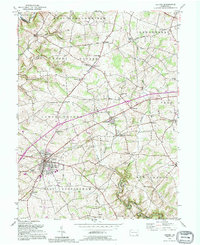
1992 Map of Oxford
USGS Topo · Published 1995About this map
Lincoln University anchors the center of this Southern Chester County landscape, a region defined by its numerous rural hamlets and the branching waters of the Elk Creek system. The map documents the intricate network of townships, including Upper Oxford, Lower Oxford, and New London, where small settlements like Hayesville and Russellville developed around historical crossroads. Significant educational and religious landmarks are scattered throughout the agricultural terrain, from the Hosannah Ch near the university to various district schoolhouses such as Buena Vista Sch and Pleasant View Sch. Transportation is represented by the Baltimore and Ohio RR and the Baltimore Pike, which provided essential links for the borough of Oxford and surrounding farms. The topography is intricately detailed, showing the varied drainages of West Branch Big Elk Creek and Little Elk Creek.
Find a feature on this map
56 named features on this map. Tap any name to fly to it.
Don’t see what you’re looking for? This feature index may not catch every label — zoom into the map to look around manually.
Map Details
Editions of this 1992 Oxford Map
2 editions found
Other maps of this area

1898 · Elkton
USGS Topo · 1:62,500

1900 · Elkton
USGS Topo · 1:62,500

1900 · Havre De Grace
USGS Topo · 1:62,500

1904 · Coatesville
USGS Topo · 1:62,500

1906 · Coatesville
USGS Topo · 1:62,500

1912 · Quarryville
USGS Topo · 1:62,500

1917 · Elkton
USGS Topo · 1:62,500

1918 · Coatesville
USGS Topo · 1:62,500

1942 · Havre De Grace
USGS Topo · 1:62,500

1942 · Elkton
USGS Topo · 1:62,500
Featured Places
- New London Township, PA
- Upper Oxford Township, PA
- Russellville, Upper Oxford Township
- Lower Oxford Township, PA
- East Nottingham Township, PA