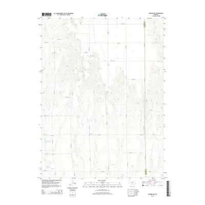
2014 Map of Oxford NW
USGS Topo · Published 2014About this map
Zion Cemetery sits at the intersection of Road 730 and Road 435, marking a historical anchor point in this agricultural region along the Gosper and Phelps county line. The landscape is defined by a sophisticated water management network of small, private reservoirs, including Ebmeier Reservoir, Walters Reservoir, and the Gardner and Gardner-Larson pools. These catchments follow the natural drainage of seasonal watercourses like Swartz Creek and East Branch Turkey Creek. The regular grid of section roads, such as County Line Road, illustrates the late-twentieth-century development of the Great Plains' rural infrastructure, where precise surveying facilitated large-scale farming and local transport across the drainage divides.
Find a feature on this map
34 named features on this map. Tap any name to fly to it.
Don’t see what you’re looking for? This feature index may not catch every label — zoom into the map to look around manually.
Map Details
Editions of this 2014 Oxford NW Map
This is the sole edition of this map. No revisions or reprints were ever made.
Other maps of this area

1896 · Lexington
USGS Topo · 1:125,000

1896 · Arapahoe
USGS Topo · 1:125,000

1898 · Arapahoe
USGS Topo · 1:125,000

1899 · Lexington
USGS Topo · 1:125,000

1955 · Grand Island
USGS Topo · 1:250,000

1957 · Grand Island
USGS Topo · 1:250,000

1958 · Grand Island
USGS Topo · 1:250,000

1958 · Edison
USGS Topo · 1:24,000

1958 · Mascot
USGS Topo · 1:24,000
1958 · Oxford
USGS Topo · 1:24,000