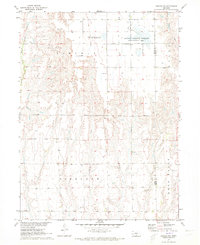
1971 Map of Oxford NW
USGS Topo · Published 1973About this map
The rolling agricultural landscape of Gosper County is defined by the headwaters of several drainages, most notably Turkey Creek and its East Branch, which carve through the Lincoln and Highland townships. In the early 1970s, this area remained primarily rural, characterized by a sparse grid of section roads and numerous water extraction points simply labeled as Well. A significant portion of the northeastern quadrant is dedicated to the Gosper National Wildlife Management Area, preserving local habitat amidst the surrounding farmland. Genealogists may find interest in the Zion Cem, located centrally in the Highland township, which serves as a quiet landmark in the prairie. The map also traces modern utility infrastructure with a prominent Pipeline crossing the southern portion of the terrain, illustrating the integration of industrial transport into the traditional plains environment.
Find a feature on this map
12 named features on this map. Tap any name to fly to it.
Don’t see what you’re looking for? This feature index may not catch every label — zoom into the map to look around manually.
Map Details
Editions of this 1971 Oxford NW Map
This is the sole edition of this map. No revisions or reprints were ever made.
Other maps of this area

1896 · Lexington
USGS Topo · 1:125,000

1896 · Arapahoe
USGS Topo · 1:125,000

1898 · Arapahoe
USGS Topo · 1:125,000

1899 · Lexington
USGS Topo · 1:125,000

1955 · Grand Island
USGS Topo · 1:250,000

1957 · Grand Island
USGS Topo · 1:250,000

1958 · Grand Island
USGS Topo · 1:250,000

1958 · Edison
USGS Topo · 1:24,000

1958 · Mascot
USGS Topo · 1:24,000
1958 · Oxford
USGS Topo · 1:24,000