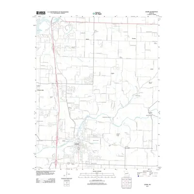
2011 Map of Ozark
USGS Topo · Published 2011About this map
Finley Creek and its many tributaries, including Garrison Branch and Parched Corn Creek, define the topography of this Christian County landscape as it appeared in the early 21st century. The area shows significant residential development south of Lake Springfield, particularly within Fremont Hills and the expanding northern reaches of Ozark. Local history and genealogy are deeply embedded in the terrain, evidenced by a high density of family-named burial grounds such as Kelly Cemetery, Gibson-Porter Cemetery, and Vaughn Cemetery. The map captures a moment of transition where traditional rural identifiers like Parched Corn Hollow and Mooney Hollow meet modern infrastructure. Transportation and aviation landmarks, including Air Park South, Sadowski Private Airport, and the Hedges Spur rail feature, highlight the region's role as a suburban and industrial corridor between Springfield and the smaller outlying settlements of McCracken and Linden.
Find a feature on this map
83 named features on this map. Tap any name to fly to it.
Don’t see what you’re looking for? This feature index may not catch every label — zoom into the map to look around manually.
Map Details
Editions of this 2011 Ozark Map
This is the sole edition of this map. No revisions or reprints were ever made.
Other maps of this area

1884 · Springfield
USGS Topo · 1:125,000

1886 · Springfield
USGS Topo · 1:125,000

1907 · Forsyth
USGS Topo · 1:125,000

1935 · Springfield
USGS Topo · 1:24,000

1937 · Galloway
USGS Topo · 1:24,000

1937 · Ozark
USGS Topo · 1:48,000

1943 · Ozark
USGS Topo · 1:62,500

1945 · Harrison
USGS Topo · 1:250,000

1945 · Ozark
USGS Topo · 1:62,500
1948 · Galloway
USGS Topo · 1:24,000