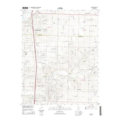
2015 Map of Ozark
USGS Topo · Published 2015About this map
Ozark and the southern fringes of Springfield serve as the primary hubs in this modern survey of the Greene Co and Christian Co border. The landscape is defined by the winding course of Finley Creek, which feeds into Lindenlure Lake near the settlement of Linden. This area is characterized by a high density of family burial grounds and community graveyards, including Kelly Cemetery, Hopewell Cemetery, and Vaughn Cemetery, providing a detailed record for genealogical research. The transition from the suburban growth of Fremont Hills and Cassidy to the more rural, hollow-riven terrain near McCracken is clearly visible. Distinctive local landmarks such as Linden Air Airport and the geological feature at Cave Hollow illustrate the varied land use across the Finley River valley before it reaches the waters of Lake Springfield to the northwest.
Find a feature on this map
111 named features on this map. Tap any name to fly to it.
Don’t see what you’re looking for? This feature index may not catch every label — zoom into the map to look around manually.
Map Details
Editions of this 2015 Ozark Map
This is the sole edition of this map. No revisions or reprints were ever made.
Other maps of this area

1884 · Springfield
USGS Topo · 1:125,000

1886 · Springfield
USGS Topo · 1:125,000

1907 · Forsyth
USGS Topo · 1:125,000

1935 · Springfield
USGS Topo · 1:24,000

1937 · Galloway
USGS Topo · 1:24,000

1937 · Ozark
USGS Topo · 1:48,000

1943 · Ozark
USGS Topo · 1:62,500

1945 · Harrison
USGS Topo · 1:250,000

1945 · Ozark
USGS Topo · 1:62,500
1948 · Galloway
USGS Topo · 1:24,000