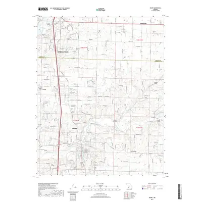
2017 Map of Ozark
USGS Topo · Published 2017About this map
Ozark and the southern reaches of Springfield anchor this 2017 survey, revealing a landscape defined by the transition from urban expansion to the rural valleys of the Finley Creek drainage. The Missouri Veterans Cem - Springfield stands as a prominent landmark near the northern edge, while the southern portion traces the winding course of Finley Creek past Linden and McCracken. This map is particularly valuable for genealogical research, documenting numerous family-named cemeteries such as Gibson-Porter Cem, Weaver Cem, and Vaughn Cem that predate the modern subdivisions. The hydrography of the area is well-defined, featuring the waters of Lake Springfield in the northwest and the recreationally significant Lindenlure Lake to the east, where several hollows like Mooney Hollow and Carter Hollow converge.
Find a feature on this map
223 named features on this map. Tap any name to fly to it.
Don’t see what you’re looking for? This feature index may not catch every label — zoom into the map to look around manually.
Map Details
Editions of this 2017 Ozark Map
This is the sole edition of this map. No revisions or reprints were ever made.
Other maps of this area

1884 · Springfield
USGS Topo · 1:125,000

1886 · Springfield
USGS Topo · 1:125,000

1907 · Forsyth
USGS Topo · 1:125,000

1935 · Springfield
USGS Topo · 1:24,000

1937 · Galloway
USGS Topo · 1:24,000

1937 · Ozark
USGS Topo · 1:48,000

1943 · Ozark
USGS Topo · 1:62,500

1945 · Harrison
USGS Topo · 1:250,000

1945 · Ozark
USGS Topo · 1:62,500
1948 · Galloway
USGS Topo · 1:24,000