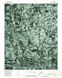
1979 Map of Ozark
USGS Topo · Published 1981About this map
Ozark serves as the central hub of this Missouri orthophotograph, where the winding course of Finley Creek meets the developed street grid of the town. The 1979 aerial imagery reveals the transition from concentrated residential and commercial blocks into the surrounding patchwork of agricultural fields and woodlots that characterize the Christian County landscape. To the north and east, smaller settlements like Mentor, Cassidy, and Linden are visible as clusters of structures amidst a grid of rural roads. The confluence of the James River and Finley Creek provides a clear view of the natural drainage patterns and riparian corridors that influenced the location of historic communities and later rural development. This survey captures a moment in time just before significant suburban expansion, documenting the established footprints of Mc Cracken and other local landmarks against the late 1970s terrain.
Find a feature on this map
7 named features on this map. Tap any name to fly to it.
Don’t see what you’re looking for? This feature index may not catch every label — zoom into the map to look around manually.
Map Details
Editions of this 1979 Ozark Map
This is the sole edition of this map. No revisions or reprints were ever made.
Other maps of this area

1884 · Springfield
USGS Topo · 1:125,000

1886 · Springfield
USGS Topo · 1:125,000

1907 · Forsyth
USGS Topo · 1:125,000

1935 · Springfield
USGS Topo · 1:24,000

1937 · Galloway
USGS Topo · 1:24,000

1937 · Ozark
USGS Topo · 1:48,000

1943 · Ozark
USGS Topo · 1:62,500

1945 · Harrison
USGS Topo · 1:250,000

1945 · Ozark
USGS Topo · 1:62,500
1948 · Galloway
USGS Topo · 1:24,000