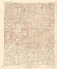
1936 Map of Ozone
USGS Topo · Published 1936About this map
Boston Mountains topography dominates this mid-1930s survey of the Arkansas interior, where the Mulberry River and Piney Creek carve deep valleys through a series of high ridges and knobs. The landscape is dotted with dispersed mountain communities and family-named landmarks like the Gillian Settlement and Strawberry Settlement. Transportation at this time relied on routes such as the Porter Highway and State Highway No 21, connecting remote settlements to local hubs like Ozone and Hagarville.
Find a feature on this map
105 named features on this map. Tap any name to fly to it.
Don’t see what you’re looking for? This feature index may not catch every label — zoom into the map to look around manually.
Map Details
Editions of this 1936 Ozone Map
3 editions found

Other maps of this area

1887 · Magazine Mountain #1
USGS Topo · 1:62,500

1887 · Magazine Mountain
USGS Topo · 1:62,500

1888 · Dardanelle #2
USGS Topo · 1:62,500

1888 · Dardanelle #1
USGS Topo · 1:62,500

1889 · Treat
USGS Topo · 1:62,500

1889 · Ozone
USGS Topo · 1:62,500

1890 · Magazine Mountain
USGS Topo · 1:125,000

1890 · Dardanelle
USGS Topo · 1:125,000

1906 · Batson
USGS Topo · 1:62,500

1932 · Treat
USGS Topo · 1:62,500