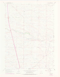
1962 Map of P O Ranch
USGS Topo · Published 1978About this map
P O Ranch serves as the namesake landmark for this Laramie County landscape, characterized by the expansive grazing lands and drainage systems typical of the high plains in the early 1960s. The map illustrates a rural social fabric through essential community sites like Goggins School and Ridley Sch, reflecting a time when localized school districts anchored these ranching territories. The topography is defined by the winding course of Lodgepole Creek, which is augmented by the North Lodgepole Ditch, indicating the vital importance of water management in this environment. Transportation and industry are noted via the Indian Hill Road and scattered Gravel Pits, while natural depressions such as Peach Lake, Chivington Draw, and Ninemile Draw provide the primary geographical relief across the rolling terrain.
Find a feature on this map
12 named features on this map. Tap any name to fly to it.
Don’t see what you’re looking for? This feature index may not catch every label — zoom into the map to look around manually.
Map Details
Editions of this 1962 P O Ranch Map
2 editions found
Other maps of this area

1911 · Cheyenne
USGS Topo · 1:125,000

1914 · Cheyenne
USGS Topo · 1:125,000

1950 · Cheyenne
USGS Topo · 1:62,500

1954 · Cheyenne
USGS Topo · 1:250,000

1958 · Cheyenne
USGS Topo · 1:250,000

1961 · Round Top Lake
USGS Topo · 1:24,000

1961 · Cheyenne
USGS Topo · 1:62,500

1961 · Cheyenne North
USGS Topo · 1:24,000

1962 · P O Ranch
USGS Topo · 1:24,000
1962 · Farthing Ranch
USGS Topo · 1:24,000