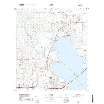
2021 Map of Pace
USGS Topo · Published 2021About this map
The Escambia River and its intricate network of bayous and islands define the landscape between Pace and Pensacola in this modern survey. The river's lower basin is a labyrinth of secondary channels and cutoffs, including the Seedland Cutoff and Dead River, creating major landforms like Brosnaham Island and Noriegas Island. This waterway complexity contrasts with the intensive upland development seen in suburban communities like Ferry Pass and Floridatown.
Find a feature on this map
131 named features on this map. Tap any name to fly to it.
Don’t see what you’re looking for? This feature index may not catch every label — zoom into the map to look around manually.
Map Details
Editions of this 2021 Pace Map
This is the sole edition of this map. No revisions or reprints were ever made.
Other maps of this area

1920 · Milton
USGS Topo · 1:62,500

1921 · Pensacola
USGS Topo · 1:62,500

1921 · Fort Barrancas
USGS Topo · 1:62,500

1921 · Muscogee
USGS Topo · 1:62,500

1941 · Fort Barrancas
USGS Topo · 1:62,500

1941 · Muscogee
USGS Topo · 1:62,500

1941 · Pensacola
USGS Topo · 1:62,500

1941 · Milton
USGS Topo · 1:62,500

1942 · Pensacola
USGS Topo · 1:62,500

1943 · Muscogee
USGS Topo · 1:62,500