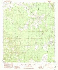
1983 Map of Pachuta
USGS Topo · Published 1983About this map
The Southern railroad line serves as a central spine for the landscape of eastern Jasper and western Clarke Counties, connecting the town of Pachuta to the settlement of Beatrice. This 1983 provisional survey shows a rural interior defined by a dense network of tributaries including Chicwillasaw Creek, Pachuta Creek, and Souenlouie Creek. The map records a community structure anchored by numerous country churches, such as Mt Jordan Ch, Homewood Ch, and Phalti Ch, which often sit adjacent to small agricultural clearings within the timbered terrain.
Find a feature on this map
25 named features on this map. Tap any name to fly to it.
Don’t see what you’re looking for? This feature index may not catch every label — zoom into the map to look around manually.
Map Details
Editions of this 1983 Pachuta Map
This is the sole edition of this map. No revisions or reprints were ever made.
Other maps of this area

1953 · Hattiesburg
USGS Topo · 1:250,000

1953 · Meridian
USGS Topo · 1:250,000

1957 · Meridian
USGS Topo · 1:250,000

1957 · Enterprise
USGS Topo · 1:62,500

1958 · Hattiesburg
USGS Topo · 1:250,000

1963 · Waldrup
USGS Topo · 1:24,000

1963 · Heidelberg
USGS Topo · 1:24,000

1964 · Hale
USGS Topo · 1:24,000

1965 · Meridian
USGS Topo · 1:250,000

1970 · Paulding
USGS Topo · 1:24,000