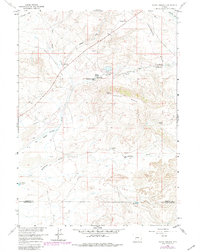
1958 Map of Pacific Springs
USGS Topo · Published 1980About this map
The Continental Divide cuts through this high-altitude landscape, marking a crucial crossing point for westward migration across the American West. At the heart of the terrain lies South Pass, with several markers identifying the Summit of the Original South Pass and various Historical Monuments. The historic Emigrant Trail and the Lander Pinedale Stage Road converge near the Pacific Springs Stage and Pony Express Sta Site, indicating the vital role this water source played for travelers on the Oregon and California trails.
Find a feature on this map
24 named features on this map. Tap any name to fly to it.
Don’t see what you’re looking for? This feature index may not catch every label — zoom into the map to look around manually.
Map Details
Editions of this 1958 Pacific Springs Map
3 editions found
Other maps of this area

1953 · South Pass City
USGS Topo · 1:24,000

1955 · Lander
USGS Topo · 1:250,000

1958 · Lander
USGS Topo · 1:250,000

1958 · Parting of the Ways
USGS Topo · 1:62,500

1958 · Essex Mountain
USGS Topo · 1:62,500

1958 · Hay Meadow Reservoir
USGS Topo · 1:24,000

1958 · Pacific Springs
USGS Topo · 1:24,000

1958 · Freighter Gap
USGS Topo · 1:62,500

1958 · Dickie Springs
USGS Topo · 1:24,000

1961 · Lander
USGS Topo · 1:250,000