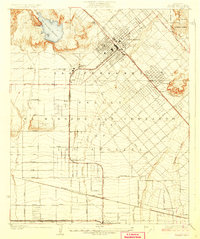
1927 Map of Pacoima
USGS Topo · Published 1927About this map
The San Fernando Mission stands as a central historical anchor in this northern portion of the San Fernando Valley, marking a landscape in the midst of a transition from its vast ranching origins toward planned suburban growth. Recorded shortly after the mid-1920s, the map reveals the complex boundary of Ex Mission San Fernando and the established town centers of San Fernando and Pacoima. The infrastructure of early Los Angeles is clearly visible, featuring the sprawling San Fernando Reservoir and the intersection of the Southern Pacific Railroad with the Pacific Electric lines. Large tracts of land remain relatively open, particularly around Mission Acres and Valley Ranch, though a dense grid of streets like Sepulveda Boulevard and Van Nuys Boulevard is already being laid out. Local civic life is represented by the Saticoy School, while the northeast corner rises into the foothills of the Angeles National Forest.
Find a feature on this map
45 named features on this map. Tap any name to fly to it.
Don’t see what you’re looking for? This feature index may not catch every label — zoom into the map to look around manually.
Map Details
Editions of this 1927 Pacoima Map
4 editions found
Other maps of this area

1894 · Los Angeles
USGS Topo · 1:62,500

1896 · Santa Monica
USGS Topo · 1:62,500

1898 · Santa Monica
USGS Topo · 1:62,500

1900 · Los Angeles
USGS Topo · 1:62,500

1900 · Fernando
USGS Topo · 1:62,500

1901 · Southern California Sheet No. 1
USGS Topo · 1:250,000

1902 · Santa Monica
USGS Topo · 1:62,500

1903 · Calabasas
USGS Topo · 1:62,500

1903 · Camulos
USGS Topo · 1:125,000

1903 · Santa Susana
USGS Topo · 1:62,500