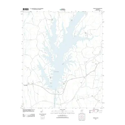
2012 Map of Paden SE
USGS Topo · Published 2012About this map
Bay Springs Lake dominates this portion of Mississippi, where the sprawling reservoir meets the Bay Springs Resource Area. The landscape is a complex network of inlets and creek branches, including Mackeys Creek and Little Brown Cr. The settlement of East Prentiss anchors the western edge, providing a focal point for the surrounding rural communities. Historical depth is evident in the high density of family and community burial grounds scattered across the terrain, from the Old Mackeys Creek Cem and Trollinger Cem near the water's edge to the Fairview Cem further inland.
Find a feature on this map
84 named features on this map. Tap any name to fly to it.
Don’t see what you’re looking for? This feature index may not catch every label — zoom into the map to look around manually.
Map Details
Editions of this 2012 Paden SE Map
This is the sole edition of this map. No revisions or reprints were ever made.
Other maps of this area

1935 · Holcut
USGS Topo · 1:24,000

1936 · Belmont
USGS Topo · 1:24,000

1936 · Red Bay
USGS Topo · 1:24,000

1936 · Tishomingo
USGS Topo · 1:24,000

1950 · Paden
USGS Topo · 1:24,000

1950 · Altitude
USGS Topo · 1:24,000

1950 · Belmont
USGS Topo · 1:24,000
1950 · Tishomingo
USGS Topo · 1:24,000

1951 · Red Bay
USGS Topo · 1:24,000
1951 · Belmont
USGS Topo · 1:24,000