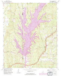
1992 Map of Paden SE
USGS Topo · Published 1995About this map
Bay Springs Lake dominates this landscape along the border of Prentiss and Tishomingo Counties, created by the massive engineering of the Bay Springs Lock and Dam. This map reflects the significant 1990s environmental changes brought by the Tennessee-Tombigbee Waterway, which transformed the former creek valleys into a major aquatic corridor. Despite the inundation, the surrounding hills retain many generational landmarks, including the Old Mackeys Creek Cem and Cotton Springs Cem.
Find a feature on this map
37 named features on this map. Tap any name to fly to it.
Don’t see what you’re looking for? This feature index may not catch every label — zoom into the map to look around manually.
Map Details
Editions of this 1992 Paden SE Map
This is the sole edition of this map. No revisions or reprints were ever made.
Other maps of this area

1935 · Holcut
USGS Topo · 1:24,000

1936 · Belmont
USGS Topo · 1:24,000

1936 · Red Bay
USGS Topo · 1:24,000

1936 · Tishomingo
USGS Topo · 1:24,000

1950 · Paden
USGS Topo · 1:24,000

1950 · Altitude
USGS Topo · 1:24,000

1950 · Belmont
USGS Topo · 1:24,000
1950 · Tishomingo
USGS Topo · 1:24,000

1951 · Red Bay
USGS Topo · 1:24,000
1951 · Belmont
USGS Topo · 1:24,000