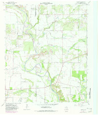
1964 Map of Padgett
USGS Topo · Published 1982About this map
The Brazos River snakes through the center of this landscape, forming a natural boundary line between Throckmorton and Young Counties. The small settlements of Padgett and Elbert serve as the primary hubs in an area defined by its hydrology and mineral extraction. Multiple watercourses, including Spring Creek, Bitter Creek, and Leopard Creek, drain into the Brazos, while the terrain is dotted with several Oil Wells and Gravel Pits, indicating the economic activities of the early 1960s.
Find a feature on this map
19 named features on this map. Tap any name to fly to it.
Don’t see what you’re looking for? This feature index may not catch every label — zoom into the map to look around manually.
Map Details
Editions of this 1964 Padgett Map
2 editions found
Other maps of this area

1954 · Wichita Falls
USGS Topo · 1:250,000

1958 · Wichita Falls
USGS Topo · 1:250,000

1963 · Megargel
USGS Topo · 1:24,000

1964 · Padgett
USGS Topo · 1:24,000
1964 · Lake Olney
USGS Topo · 1:24,000

1964 · Olney
USGS Topo · 1:24,000

1965 · Throckmorton NE
USGS Topo · 1:24,000

1966 · Westover SE
USGS Topo · 1:24,000
1966 · Proffitt
USGS Topo · 1:24,000
1966 · Westover
USGS Topo · 1:24,000