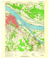
1958 Map of Paducah East
USGS Topo · Published 1959About this map
The confluence of the Ohio River and Tennessee River defines the landscape of this 1950s riverport hub, where the growing city of Paducah expands eastward into Tyler and Woodlawn. The urban grid is dense with civic infrastructure, including St Marys Academy, Lincoln High Sch, and the riverside pumping station. Across the water, the Clark Memorial Bridge provides the vital link to Brookport in Illinois, while the Paducah and Illinois Railroad spans the river toward the agricultural lowlands of Black Bottom. Beyond the city limits, the terrain transitions into a patchwork of rural homesteads and wetlands, featuring family landmarks like Allard Cem and the minnow rearing pools near Reidland. The map captures a moment of mid-century development, where traditional river-based industry meets suburban expansion and established neighborhood schools.
Find a feature on this map
68 named features on this map. Tap any name to fly to it.
Don’t see what you’re looking for? This feature index may not catch every label — zoom into the map to look around manually.
Map Details
Editions of this 1958 Paducah East Map
3 editions found
Other maps of this area

1926 · Paducah
USGS Topo · 1:62,500

1929 · Smithland
USGS Topo · 1:62,500

1929 · Paducah
USGS Topo · 1:62,500

1936 · Melber
USGS Topo · 1:24,000

1936 · Paducah
USGS Topo · 1:24,000

1936 · Elva
USGS Topo · 1:24,000

1936 · Smithland
USGS Topo · 1:48,000

1936 · Symsonia
USGS Topo · 1:24,000

1936 · Benton
USGS Topo · 1:48,000

1936 · Little Cypress
USGS Topo · 1:24,000