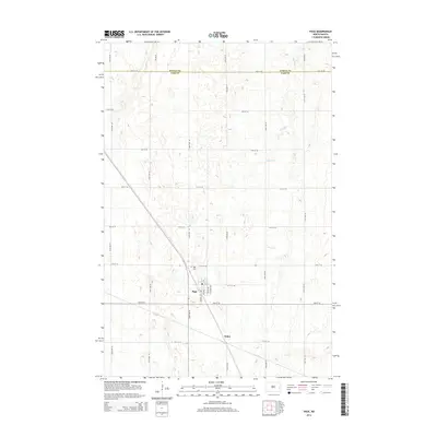
2014 Map of Page
USGS Topo · Published 2014About this map
Page serves as a central hub in this agricultural landscape near the Steele and Cass County line. The settlement layout is defined by a grid of named streets including Morton Ave, JB James Ave, and Argus Ave, with a local Po marking the center of community life. To the north, the Page Cem provides a focal point for genealogical interest, while the winding course of the Elm River breaks the regularity of the section lines in the eastern portion of the quadrangle. South of the main town site, the location of Nolan appears along the rail line, representing the small-scale grain-loading points that historically sustained the region's economy. The surrounding terrain is meticulously mapped with five-foot contour intervals, revealing the subtle drainage patterns that feed into the river valley amidst a vast network of section roads like 17th St SE and 138th Ave SE.
Find a feature on this map
26 named features on this map. Tap any name to fly to it.
Don’t see what you’re looking for? This feature index may not catch every label — zoom into the map to look around manually.
Map Details
Editions of this 2014 Page Map
This is the sole edition of this map. No revisions or reprints were ever made.
Other maps of this area

1952 · Grand Forks
USGS Topo · 1:250,000

1956 · Grand Forks
USGS Topo · 1:250,000

1966 · Grand Forks
USGS Topo · 1:250,000

1966 · Galesburg
USGS Topo · 1:24,000

1966 · Hope SE
USGS Topo · 1:24,000

1967 · Page SE
USGS Topo · 1:24,000

1967 · Ayr NW
USGS Topo · 1:24,000

1967 · Page
USGS Topo · 1:24,000
1967 · Page SW
USGS Topo · 1:24,000

1967 · Colgate
USGS Topo · 1:24,000