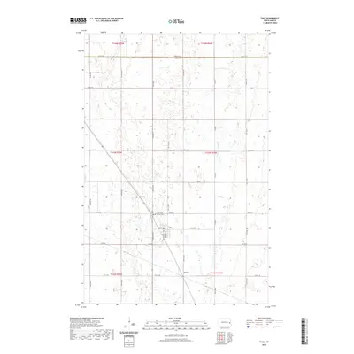
2020 Map of Page
USGS Topo · Published 2020About this map
The agricultural landscape of the Red River Valley is defined here by the structured grid of Section 13 and 14 townships near the Steele County and Cass County line. The community of Page serves as the primary hub, where local history is anchored by the Page Cemetery and the Saint James Catholic Cemetery. These burial grounds, located northwest of the town center, provide essential records for genealogists studying the early settlement of this prairie region. To the east, the meandering course of the Elm River breaks the geometry of the surrounding section roads, such as County Road 3 and 12th St SE. Further south, the map identifies the location of Nolan, illustrating the sparse but deliberate distribution of rail-and-road settlements that once facilitated the transport of grain and goods across the North Dakota plains.
Find a feature on this map
32 named features on this map. Tap any name to fly to it.
Don’t see what you’re looking for? This feature index may not catch every label — zoom into the map to look around manually.
Map Details
Editions of this 2020 Page Map
This is the sole edition of this map. No revisions or reprints were ever made.
Other maps of this area

1952 · Grand Forks
USGS Topo · 1:250,000

1956 · Grand Forks
USGS Topo · 1:250,000

1966 · Grand Forks
USGS Topo · 1:250,000

1966 · Galesburg
USGS Topo · 1:24,000

1966 · Hope SE
USGS Topo · 1:24,000

1967 · Page SE
USGS Topo · 1:24,000

1967 · Ayr NW
USGS Topo · 1:24,000

1967 · Page
USGS Topo · 1:24,000
1967 · Page SW
USGS Topo · 1:24,000

1967 · Colgate
USGS Topo · 1:24,000