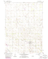
1958 Map of Page
USGS Topo · Published 1986About this map
Page serves as the primary hub of this Nebraska plains landscape, situated along the Burlington Northern railroad line in Holt County. The town's grid and nearby rural sections reflect the agricultural surveying of the mid-20th century, where distance was still measured by the placement of local institutions like School No 128 and School No 23. The terrain is defined by its water features, notably the Elkhorn R at the southern edge and the Chain Lakes in the southwest, suggesting a landscape of low-lying wetlands and river valleys. Small industrial markers like the Gravel Pit near the village highlight the localized extraction necessary for maintaining the early road networks connecting these prairie townships. To the northeast, the flow of Verdigre Creek cuts through the sections, framing a quiet corner of the state during a period of steady rural character.
Find a feature on this map
9 named features on this map. Tap any name to fly to it.
Don’t see what you’re looking for? This feature index may not catch every label — zoom into the map to look around manually.
Map Details
Editions of this 1958 Page Map
4 editions found
Other maps of this area

1954 · Dorsey SW
USGS Topo · 1:24,000

1954 · Opportunity
USGS Topo · 1:24,000

1954 · Star
USGS Topo · 1:24,000

1955 · O'Neill
USGS Topo · 1:250,000

1958 · Inman
USGS Topo · 1:24,000

1958 · Page
USGS Topo · 1:24,000

1959 · O'Neill
USGS Topo · 1:250,000

1963 · Ewing SW
USGS Topo · 1:24,000

1963 · Venus
USGS Topo · 1:24,000

1963 · Ewing
USGS Topo · 1:24,000