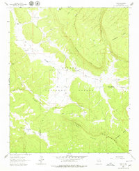
1962 Map of Page
USGS Topo · Published 1979About this map
Cibola National Forest encompasses much of this landscape in the Zuni Mountains, where high ridges and canyons define the local topography. The Continental Divide winds through the eastern portion of the map, marking the high ground between watersheds. The land is dotted with family-named locations such as Radosevich Ranch, Polich Place, and Merrill Place, suggesting a history of high-altitude ranching and homesteading. These small outposts are connected by primitive tracks and a Jeep Trail that traverse the rugged elevations. Water sources are critical in this environment, evidenced by the presence of Rio Nutria, Natural Lake, and several isolated springs like Bear Spring. Near the center of the survey, the small settlement of Page sits along the Mc Que Flat, while the border between McKinley and Valencia counties cuts across the southern ridges.
Find a feature on this map
32 named features on this map. Tap any name to fly to it.
Don’t see what you’re looking for? This feature index may not catch every label — zoom into the map to look around manually.
Map Details
Editions of this 1962 Page Map
3 editions found

Other maps of this area

1886 · Wingate
USGS Topo · 1:250,000

1892 · Wingate
USGS Topo · 1:250,000

1954 · Gallup
USGS Topo · 1:250,000

1958 · Gallup
USGS Topo · 1:250,000

1959 · Gallup
USGS Topo · 1:250,000

1961 · Cottonwood Canyon
USGS Topo · 1:24,000

1962 · Gallup
USGS Topo · 1:250,000

1962 · Ciniza
USGS Topo · 1:24,000

1962 · Continental Divide
USGS Topo · 1:24,000

1962 · Cottonwood Canyon
USGS Topo · 1:24,000