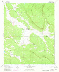
1962 Map of Page
USGS Topo · Published 1981About this map
Cibola National Forest encompasses the rugged high-country landscape on this topographic survey, which was field-checked in the early 1960s and updated with purple revisions in 1980. The Continental Divide winds across the eastern ridges of the Zuni Mountains, serving as a primary geographic anchor for the region. The settlement pattern here is characterized by isolated homesteads and family-named landmarks rather than dense townships. Notable locations such as Basgal Place, Radosevich Ranch, and Navarre Place are scattered across the terrain, connected by unimproved roads and a Jeep Trail. Drainages like Rio Nutria and Sixmile Draw define the lower elevations, while Bloomfield Flat and McQue Flat provide rare stretches of level ground amidst the prominent features of Oso Ridge and McKenzie Ridge.
Find a feature on this map
27 named features on this map. Tap any name to fly to it.
Don’t see what you’re looking for? This feature index may not catch every label — zoom into the map to look around manually.
Map Details
Editions of this 1962 Page Map
3 editions found

Other maps of this area

1886 · Wingate
USGS Topo · 1:250,000

1892 · Wingate
USGS Topo · 1:250,000

1954 · Gallup
USGS Topo · 1:250,000

1958 · Gallup
USGS Topo · 1:250,000

1959 · Gallup
USGS Topo · 1:250,000

1961 · Cottonwood Canyon
USGS Topo · 1:24,000

1962 · Gallup
USGS Topo · 1:250,000

1962 · Ciniza
USGS Topo · 1:24,000

1962 · Continental Divide
USGS Topo · 1:24,000

1962 · Cottonwood Canyon
USGS Topo · 1:24,000