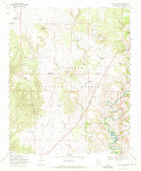
1969 Map of Page Springs
USGS Topo · Published 1971About this map
Page Springs serves as a focal point in this high-desert landscape, where the waters of Oak Creek and various perennial springs supported diverse land uses in the late 1960s. The presence of the Page Springs State Fish Cultural Station and the Christian Indian Sch indicates a specialized community focused on conservation and education near the riparian corridor. The area's agricultural and ranching footprint is evidenced by clusters of infrastructure such as Windmill Ranch and Deer Pass Ranch, while the surrounding Coconino National Forest is dotted with numerous water tanks like Skeleton Bone Tank and Dutch Kid Tank, essential for livestock management in the arid uplands. Higher elevations are defined by prominent landmarks including Anderson Butte and Windmill Mtn, with signs of mineral exploration found at various prospects north of Black Mountain.
Find a feature on this map
53 named features on this map. Tap any name to fly to it.
Don’t see what you’re looking for? This feature index may not catch every label — zoom into the map to look around manually.
Map Details
Editions of this 1969 Page Springs Map
4 editions found
Other maps of this area

1887 · Verde
USGS Topo · 1:250,000

1887 · Prescott
USGS Topo · 1:250,000

1892 · Verde
USGS Topo · 1:250,000

1892 · Prescott
USGS Topo · 1:250,000

1905 · Jerome
USGS Topo · 1:125,000

1923 · Camp Verde
USGS Topo · 1:125,000

1932 · Camp Verde
USGS Topo · 1:125,000

1936 · Camp Verde
USGS Topo · 1:125,000

1944 · Clarkdale
USGS Topo · 1:48,000

1944 · Mingus Mountain
USGS Topo · 1:62,500