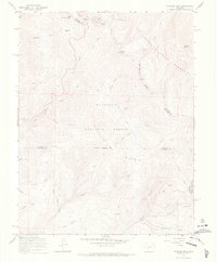
1967 Map of Pahlone Peak
USGS Topo · Published 1969About this map
The Continental Divide snakes through this high-altitude landscape in the late 1960s, marking the border between the Gunnison National Forest and the San Isabel National Forest. This survey captures the transition from traditional pack trails to mid-century industrial infrastructure, such as the Marshall Pipeline and the Larkspur Ditch. The presence of the Pinnacle Mine and other unnamed mine sites near Lime Ridge reflects the enduring mineral interest in the Sawatch Range, while the legacy of early transcontinental travel is preserved at Old Monarch Pass. The area is defined by its complex hydrology, with numerous drainages like Agate Creek, Millswitch Creek, and Harry Creek descending from peaks like Pahlone Peak and Mount Peck.
Find a feature on this map
34 named features on this map. Tap any name to fly to it.
Don’t see what you’re looking for? This feature index may not catch every label — zoom into the map to look around manually.
Map Details
Editions of this 1967 Pahlone Peak Map
4 editions found

Other maps of this area

1940 · Garfield
USGS Topo · 1:62,500

1945 · Garfield
USGS Topo · 1:62,500

1956 · Poncha Springs
USGS Topo · 1:62,500

1956 · Montrose
USGS Topo · 1:250,000

1959 · Montrose
USGS Topo · 1:250,000

1959 · Bonanza
USGS Topo · 1:62,500

1960 · Montrose
USGS Topo · 1:250,000

1964 · Sargents
USGS Topo · 1:24,000

1967 · Sargents Mesa
USGS Topo · 1:24,000

1967 · Chester
USGS Topo · 1:24,000