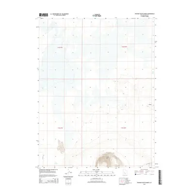
2014 Map of Pahvant Butte North
USGS Topo · Published 2014About this map
Pahvant Butte dominates the southern landscape of this Millard County quadrant, its distinct volcanic form rising sharply above the surrounding desert floor. This 2014 survey captures a sparsely populated stretch of the Sevier Desert, where the primary infrastructure consists of isolated tracks like Sheep Trail Rd and W 14800 S St. The presence of Mud Lake Spring and Mud Springs indicates the critical importance of water sources in this arid environment, while the curious elevation known as Knobby serves as a lone topographic landmark to the northeast. These features illustrate the enduring character of the Great Basin terrain, mapped during an era of modern digital precision while still reflecting the fundamental reliance on natural springs and historic livestock routes.
Find a feature on this map
10 named features on this map. Tap any name to fly to it.
Don’t see what you’re looking for? This feature index may not catch every label — zoom into the map to look around manually.
Map Details
Editions of this 2014 Pahvant Butte North Map
This is the sole edition of this map. No revisions or reprints were ever made.
Other maps of this area

1885 · Sevier Desert
USGS Topo · 1:250,000

1951 · Oak City
USGS Topo · 1:62,500

1953 · Delta
USGS Topo · 1:250,000

1958 · Delta
USGS Topo · 1:250,000

1962 · Delta
USGS Topo · 1:250,000
1962 · The Sink
USGS Topo · 1:24,000

1962 · Holden
USGS Topo · 1:62,500

1962 · Delta
USGS Topo · 1:62,500

1971 · Pavant Butte North
USGS Topo · 1:24,000

1971 · Sunstone Knoll
USGS Topo · 1:24,000