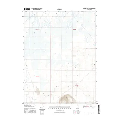
2017 Map of Pahvant Butte North
USGS Topo · Published 2017About this map
Pahvant Butte dominates the southern reaches of this Millard County landscape, rising sharply from the surrounding desert basin. This 2017 survey reveals a terrain defined by sparse water sources and distinct geological formations, characteristic of the Sevier Desert. The presence of Mud Lake Spring in the northeast and Mud Springs to the southwest suggests the critical, localized points of hydration that have historically dictated movement and land use in this arid region. The map also identifies Knobby, a localized high point that serves as a landmark for navigation across the open sagebrush and salt flats. The grid of the Public Land Survey System, including t18s r6w and t19s r7w, provides the framework for this largely undeveloped territory, where the interplay of contour lines and scattered wetlands highlights the subtle drainage patterns of the basin floor.
Find a feature on this map
8 named features on this map. Tap any name to fly to it.
Don’t see what you’re looking for? This feature index may not catch every label — zoom into the map to look around manually.
Map Details
Editions of this 2017 Pahvant Butte North Map
This is the sole edition of this map. No revisions or reprints were ever made.
Other maps of this area

1885 · Sevier Desert
USGS Topo · 1:250,000

1951 · Oak City
USGS Topo · 1:62,500

1953 · Delta
USGS Topo · 1:250,000

1958 · Delta
USGS Topo · 1:250,000

1962 · Delta
USGS Topo · 1:250,000
1962 · The Sink
USGS Topo · 1:24,000

1962 · Holden
USGS Topo · 1:62,500

1962 · Delta
USGS Topo · 1:62,500

1971 · Pavant Butte North
USGS Topo · 1:24,000

1971 · Sunstone Knoll
USGS Topo · 1:24,000