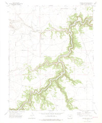
1972 Map of Painted Canyon
USGS Topo · Published 1975About this map
The Purgatoire River carves a deep, winding path through this portion of Las Animas County, creating a dramatic corridor of side canyons and tributary drainages. Surveyed in the early 1970s, the landscape is defined by its complex hydrology, where seasonal flows like the Van Bremer Arroyo and Luning Arroyo meet the main river channel. Named geographical features such as The Hogback and Painted Canyon suggest a terrain of sharp elevations and distinct geological formations, while the presence of a Gaging Sta and Water Tanks indicates the critical management of water resources in this arid region. Traces of human infrastructure are minimal but strategic, including a prominent Pipeline and scattered springs like Jack Canyon Spring. This map captures the intersection of deep-cut river valleys and high plains before modern development could alter its traditional land-use patterns, centered around numerous named canyons such as Gutierrez Canyon and Hunt Canyon.
Find a feature on this map
16 named features on this map. Tap any name to fly to it.
Don’t see what you’re looking for? This feature index may not catch every label — zoom into the map to look around manually.
Map Details
Editions of this 1972 Painted Canyon Map
4 editions found
Other maps of this area

1891 · Mesa De Maya
USGS Topo · 1:125,000

1892 · Elmoro
USGS Topo · 1:125,000

1893 · Elmoro
USGS Topo · 1:125,000

1893 · Mesa de Maya
USGS Topo · 1:125,000

1897 · Elmoro
USGS Topo · 1:125,000

1954 · Trinidad
USGS Topo · 1:250,000

1955 · La Junta
USGS Topo · 1:250,000

1955 · Trinidad
USGS Topo · 1:250,000

1958 · La Junta
USGS Topo · 1:250,000

1958 · Trinidad
USGS Topo · 1:250,000