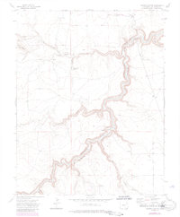
1972 Map of Painted Canyon
USGS Topo · Published 1985About this map
The Purgatoire River Canyon dominates this 1972 survey of the high plains in Las Animas County, carving a deep, winding path through the arid landscape. This specific reach of the Purgatoire River exhibits dramatic entrenched meanders, a characteristic topographical feature of the region's erosion history. The terrain is defined by a network of drainage systems that feed into the main canyon, including Van Bremer Arroyo, Luning Arroyo, and Hunt Canyon. To the northwest, the prominent ridge of The Hogback rises above the plains, while isolated water sources like Jack Canyon Spring provide critical landmarks in a region largely defined by dry washes. The presence of a Gaging Sta and scattered wells indicates the essential role of water management in this cattle-ranching territory, where landmarks such as Painted Canyon and Gutierrez Canyon navigate a landscape of high mesas and deep breaks.
Find a feature on this map
24 named features on this map. Tap any name to fly to it.
Don’t see what you’re looking for? This feature index may not catch every label — zoom into the map to look around manually.
Map Details
Editions of this 1972 Painted Canyon Map
4 editions found
Other maps of this area

1891 · Mesa De Maya
USGS Topo · 1:125,000

1892 · Elmoro
USGS Topo · 1:125,000

1893 · Elmoro
USGS Topo · 1:125,000

1893 · Mesa de Maya
USGS Topo · 1:125,000

1897 · Elmoro
USGS Topo · 1:125,000

1954 · Trinidad
USGS Topo · 1:250,000

1955 · La Junta
USGS Topo · 1:250,000

1955 · Trinidad
USGS Topo · 1:250,000

1958 · La Junta
USGS Topo · 1:250,000

1958 · Trinidad
USGS Topo · 1:250,000