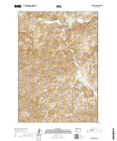
2020 Map of Painted Hills
USGS Topo · Published 2020About this map
John Day Fossil Beds National Monument anchors the southeastern portion of this landscape, where the deeply eroded colorful strata of the Painted Hills reveal millions of years of geological history. The terrain is defined by a dense network of canyons and gulches, including Coyote Canyon, Lockwood Canyon, and Shaw Canyon, which drain toward the north and east. The John Day River, designated here as the John Day Wild and Scenic River, cuts across the northern edge of the sheet, providing a vital water source in this arid environment. Human imprints are primarily found in the rural road network, with Burnt Ranch Rd and Bear Creek Rd connecting remote ranching areas. High points like Carroll Rim and Rainbow Hill overlook the Painted Hills Reservoir, marking a landscape where natural conservation and traditional land use intersect.
Find a feature on this map
29 named features on this map. Tap any name to fly to it.
Don’t see what you’re looking for? This feature index may not catch every label — zoom into the map to look around manually.
Map Details
Editions of this 2020 Painted Hills Map
This is the sole edition of this map. No revisions or reprints were ever made.
Other maps of this area

1926 · Mitchell
USGS Topo · 1:125,000

1955 · Bend
USGS Topo · 1:250,000

1957 · Bend
USGS Topo · 1:250,000

1958 · Bend
USGS Topo · 1:250,000

1966 · Mitchell
USGS Topo · 1:62,500

1966 · Kinzua
USGS Topo · 1:62,500

1966 · Clarno
USGS Topo · 1:62,500

1968 · Painted Hills
USGS Topo · 1:24,000

1968 · Lawson Mtn
USGS Topo · 1:24,000

1968 · Stephenson Mtn
USGS Topo · 1:24,000