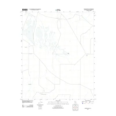
2012 Map of Painted Rock
USGS Topo · Published 2012About this map
Soda Lake dominates the northwest corner of this San Luis Obispo County survey, sitting within the larger expanse of the Carrizo Plain. This arid landscape is defined by its sparse pastoral infrastructure and a network of unpaved transit routes, including Soda Lake Rd and the lengthy Simmler Soda Lake San Diego Cr Rd. Small-scale agricultural and ranching operations are dotted across the valley floor, represented by the R C Farm, Painted Rock Ranch, and remote outposts such as Sheep Camp and the Selby Ranch Cow Camp. The prominent geologic formation known as Painted Rock stands as a significant landmark in the southwest, while the surrounding terrain is mapped with detailed 40-foot contours that reveal the subtle elevations of this basin-and-range environment during the early 21st century.
Find a feature on this map
12 named features on this map. Tap any name to fly to it.
Don’t see what you’re looking for? This feature index may not catch every label — zoom into the map to look around manually.
Map Details
Editions of this 2012 Painted Rock Map
This is the sole edition of this map. No revisions or reprints were ever made.
Other maps of this area

1912 · McKittrick
USGS Topo · 1:125,000

1941 · Caliente Mountain
USGS Topo · 1:62,500

1942 · Caliente Mtn
USGS Topo · 1:62,500

1943 · Simmler
USGS Topo · 1:62,500

1943 · Caliente Mtn.
USGS Topo · 1:62,500

1944 · Panorama Hills
USGS Topo · 1:31,680
1944 · Midway Peak SW
USGS Topo · 1:31,680

1948 · Bakersfield
USGS Topo · 1:250,000
1950 · Reward
USGS Topo · 1:24,000
1951 · Reward
USGS Topo · 1:24,000