1942 Map of Caliente Mtn
USGS Topo · Published 1952About this map
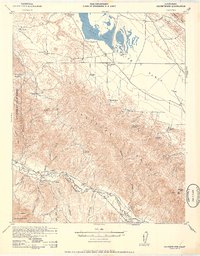
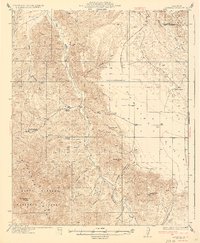
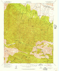
Carrizo Plain dominates the northern reaches of this map, a wide basin defined by the stark expanse of Soda Lake. This 1942 military-directed survey, reprinted for civil use, reveals an era of remote ranching and essential water management across the semi-arid landscape of the Caliente Range. Numerous family-named holdings such as Goodwin Ranch, Wellman Ranch, and Spanish Ranch are scattered throughout the territory, each strategically positioned near water sources like Turkey Camp Well or Five Willow Spring. The terrain transitions from the high peaks of Caliente Mtn and its Lookout down into the complex drainage systems of Morales Canyon and Cottonwood Canyon. Along the southern boundary, the Cuyama River carves the border between San Luis Obispo and Santa Barbara counties, serving as a vital corridor through the foothills of the Los Padres National Forest.
Find a feature on this map
34 named features on this map. Tap any name to fly to it.
Don’t see what you’re looking for? This feature index may not catch every label — zoom into the map to look around manually.
Map Details
Editions of this 1942 Caliente Mtn Map
2 editions found

Other maps of this area

1902 · Santa Ynez
USGS Topo · 1:125,000

1905 · Santa Ynez
USGS Topo · 1:125,000

1905 · Lompoc
USGS Topo · 1:125,000

1912 · McKittrick
USGS Topo · 1:125,000

1932 · La Panza
USGS Topo · 1:48,000

1935 · La Panza
USGS Topo · 1:62,500
1936 · La Panza
USGS Topo · 1:62,500

1937 · Branch Mtn
USGS Topo · 1:48,000

1941 · Caliente Mountain
USGS Topo · 1:62,500
1941 · McPherson Peak
USGS Topo · 1:62,500