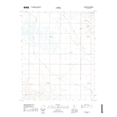
2018 Map of Painted Rock
USGS Topo · Published 2018About this map
Painted Rock sits as a landmark feature within this arid reach of San Luis Obispo County, documenting the landscape of the Carrizo Plain and its surrounding geological giants. The tectonic activity of the region is traced by the San Andreas Fault, which cuts through the terrain between the Temblor Range to the east and the Caliente Range to the southwest. This map records the basin of Soda Lake, an ephemeral alkali lake that dominates the western portion of the quadrangle. Roads such as Soda Lake Rd and Elkhorn Rd provide the primary access through the Elkhorn Plain and toward the Panorama Hills. This survey is notable for its depiction of the stark drainage patterns and land divisions across the plain, illustrating how the natural topography dictates the sparse infrastructure of this unique California interior valley.
Find a feature on this map
17 named features on this map. Tap any name to fly to it.
Don’t see what you’re looking for? This feature index may not catch every label — zoom into the map to look around manually.
Map Details
Editions of this 2018 Painted Rock Map
This is the sole edition of this map. No revisions or reprints were ever made.
Other maps of this area

1912 · McKittrick
USGS Topo · 1:125,000

1941 · Caliente Mountain
USGS Topo · 1:62,500

1942 · Caliente Mtn
USGS Topo · 1:62,500

1943 · Simmler
USGS Topo · 1:62,500

1943 · Caliente Mtn.
USGS Topo · 1:62,500

1944 · Panorama Hills
USGS Topo · 1:31,680
1944 · Midway Peak SW
USGS Topo · 1:31,680

1948 · Bakersfield
USGS Topo · 1:250,000
1950 · Reward
USGS Topo · 1:24,000
1951 · Reward
USGS Topo · 1:24,000