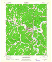
1962 Map of Paintsville
USGS Topo · Published 1964About this map
Paintsville serves as the focal point of this Johnson County landscape, where the Levisa Fork makes a deep bend through the Appalachian coal country. In the early 1960s, the region's economy was clearly defined by the Chesapeake and Ohio railroad and a dense network of mines and gas wells that dot the hillsides. The map captures an era of post-war community development, showing leisure sites like the Paintsville Golf Course and a Drive-in Theater alongside traditional centers of local life like Stafford Ch and Jennys Creek Sch.
Find a feature on this map
74 named features on this map. Tap any name to fly to it.
Don’t see what you’re looking for? This feature index may not catch every label — zoom into the map to look around manually.
Map Details
Editions of this 1962 Paintsville Map
This is the sole edition of this map. No revisions or reprints were ever made.
Other maps of this area

1886 · Prestonsburg
USGS Topo · 1:125,000

1892 · Prestonsburg
USGS Topo · 1:125,000

1914 · Laynesville
USGS Topo · 1:48,000

1914 · Inez
USGS Topo · 1:48,000

1915 · Paintsville
USGS Topo · 1:48,000

1915 · Prestonsburg
USGS Topo · 1:62,500

1916 · Harold
USGS Topo · 1:62,500

1916 · Inez
USGS Topo · 1:62,500

1917 · Paintsville
USGS Topo · 1:62,500

1918 · Prestonsburg
USGS Topo · 1:62,500