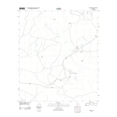
2012 Map of Paisano
USGS Topo · Published 2012About this map
Paisano Encampment and the small settlement of Toronto anchor this survey of the high-desert mountain pass landscape in West Texas. The map illustrates a region defined by critical water infrastructure in a dry environment, noting features such as Crenshaw Tank, Sunny Glen Windmill, and Good Tank. These scattered water sources are vital landmarks among the prominent topography of Crenshaw Mtn, the Black Peaks, and Paisano Peak.
Find a feature on this map
19 named features on this map. Tap any name to fly to it.
Don’t see what you’re looking for? This feature index may not catch every label — zoom into the map to look around manually.
Map Details
Editions of this 2012 Paisano Map
This is the sole edition of this map. No revisions or reprints were ever made.
Other maps of this area

1895 · Alpine
USGS Topo · 1:125,000

1954 · Fort Stockton
USGS Topo · 1:250,000

1958 · Fort Stockton
USGS Topo · 1:250,000

1972 · Alpine North
USGS Topo · 1:24,000

1972 · Paisano
USGS Topo · 1:24,000

1972 · Mitre Peak
USGS Topo · 1:24,000

1972 · Nopal
USGS Topo · 1:24,000
1972 · Mano Prieto Mountain
USGS Topo · 1:24,000

1972 · Alpine South
USGS Topo · 1:24,000

1973 · Fort Stockton
USGS Topo · 1:250,000