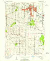
1953 Map of Palatine
USGS Topo · Published 1955About this map
Chicago and North Western rail lines anchor the growth of Palatine and neighboring Arlington Heights in the early 1950s, a period before the rapid suburbanization of the late 20th century. The landscape is a mix of developing residential grids and the rural heritage of Schaumburg and Elk Grove, where large tracts of land remain dedicated to uses like the Arlington Park Race Track and the sprawling Busse Forest Preserve.
Find a feature on this map
40 named features on this map. Tap any name to fly to it.
Don’t see what you’re looking for? This feature index may not catch every label — zoom into the map to look around manually.
Map Details
Editions of this 1953 Palatine Map
This is the sole edition of this map. No revisions or reprints were ever made.
Other maps of this area

1891 · Riverside
USGS Topo · 1:62,500

1893 · Riverside
USGS Topo · 1:62,500

1900 · Riverside
USGS Topo · 1:62,500

1900 · Highwood
USGS Topo · 1:62,500

1901 · Riverside
USGS Topo · 1:62,500

1908 · Wheaton
USGS Topo · 1:62,500

1923 · Barrington
USGS Topo · 1:62,500

1927 · Arlington Heights
USGS Topo · 1:24,000

1928 · Elmhurst
USGS Topo · 1:24,000

1928 · Wheeling
USGS Topo · 1:24,000