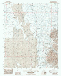
1983 Map of Palen Lake
USGS Topo · Published 1983About this map
Palen Mountains dominate the eastern edge of this arid landscape, rising sharply above the expansive basin floors. This 1983 provisional map documents a transition point between two desert corridors, with the Chuckawalla Valley to the south and the Palen Valley stretching northward. The area is characterized by vast stretches of Sand Dunes and the remnants of hydrological activity, most notably the central Dry Lake bed. A network of ephemeral drainages, labeled as Dry Wash, underscores the seasonal nature of water movement in this portion of Riverside County. The sparse collection of labels reflects an environment defined by its natural topography rather than human settlement, preserving the state of the California desert before more modern developments or conservation designations altered the management of these public lands.
Find a feature on this map
6 named features on this map. Tap any name to fly to it.
Don’t see what you’re looking for? This feature index may not catch every label — zoom into the map to look around manually.
Map Details
Editions of this 1983 Palen Lake Map
This is the sole edition of this map. No revisions or reprints were ever made.
Other maps of this area

1943 · Coxcomb Mountains
USGS Topo · 1:62,500

1944 · Chuckwalla Mountains
USGS Topo · 1:62,500

1944 · Coxcomb Mountains
USGS Topo · 1:62,500

1952 · Sidewinder Well
USGS Topo · 1:62,500

1952 · Palen Mountains
USGS Topo · 1:62,500

1954 · Salton Sea
USGS Topo · 1:250,000

1955 · Salton Sea
USGS Topo · 1:250,000

1959 · Salton Sea
USGS Topo · 1:250,000

1963 · Salton Sea
USGS Topo · 1:250,000

1963 · Chuckwalla Mountains
USGS Topo · 1:62,500