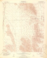
1952 Map of Palen Mountains
USGS Topo · Published 1953About this map
Palen Mountains and the Granite Mountains dominate the high desert terrain of Riverside County in this early 1950s survey. The landscape is defined by the stark transition from mountain ridges to the low-lying Chuckwalla Valley, which contains the prominent Palen Dry Lake and extensive Sand Dunes. This era captures a sparsely populated region where human presence is marked by isolated infrastructure like the Parker Highway and the remote Coxcomb Landing Strip in the northwest.
Find a feature on this map
15 named features on this map. Tap any name to fly to it.
Don’t see what you’re looking for? This feature index may not catch every label — zoom into the map to look around manually.
Map Details
Editions of this 1952 Palen Mountains Map
4 editions found

Other maps of this area

1942 · Blythe
USGS Topo · 1:250,000

1942 · Amboy
USGS Topo · 1:250,000

1943 · Amboy
USGS Topo · 1:250,000

1943 · Cadiz Valley
USGS Topo · 1:62,500

1943 · Iron Mountains
USGS Topo · 1:62,500

1943 · Coxcomb Mountains
USGS Topo · 1:62,500

1944 · Chuckwalla Mountains
USGS Topo · 1:62,500

1944 · Coxcomb Mountains
USGS Topo · 1:62,500

1945 · Midland
USGS Topo · 1:62,500

1952 · Midland
USGS Topo · 1:62,500