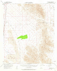
1952 Map of Palen Mountains
USGS Topo · Published 1962About this map
Chuckwalla Valley dominates this 1952 topographical study of the Colorado Desert, revealing a landscape shaped by arid drainage and early aviation infrastructure. The Parker Highway cuts through the western edge, providing access to the Coxcomb Landing Strip and the isolated Circle E Ranch. To the south, the vast Palen Dry Lake sits as a prominent basin, flanked by extensive Sand Dunes that characterize the floor of the valley.
Find a feature on this map
14 named features on this map. Tap any name to fly to it.
Don’t see what you’re looking for? This feature index may not catch every label — zoom into the map to look around manually.
Map Details
Editions of this 1952 Palen Mountains Map
4 editions found

Other maps of this area

1942 · Blythe
USGS Topo · 1:250,000

1942 · Amboy
USGS Topo · 1:250,000

1943 · Amboy
USGS Topo · 1:250,000

1943 · Cadiz Valley
USGS Topo · 1:62,500

1943 · Iron Mountains
USGS Topo · 1:62,500

1943 · Coxcomb Mountains
USGS Topo · 1:62,500

1944 · Chuckwalla Mountains
USGS Topo · 1:62,500

1944 · Coxcomb Mountains
USGS Topo · 1:62,500

1945 · Midland
USGS Topo · 1:62,500

1952 · Midland
USGS Topo · 1:62,500