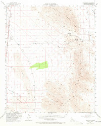
1952 Map of Palen Mountains
USGS Topo · Published 1971About this map
The Chuckwalla Valley and the surrounding desert landscape are defined by high-heat terrain and sparse outposts in this mid-century survey. Human presence is concentrated around vital infrastructure like the Colorado River Aqueduct and the isolated Coxcomb Landing Strip. To the east, the Granite Mountains and Palen Mountains rise sharply above the basin floor, connected by the high crossing at Palen Pass.
Find a feature on this map
14 named features on this map. Tap any name to fly to it.
Don’t see what you’re looking for? This feature index may not catch every label — zoom into the map to look around manually.
Map Details
Editions of this 1952 Palen Mountains Map
4 editions found

Other maps of this area

1942 · Blythe
USGS Topo · 1:250,000

1942 · Amboy
USGS Topo · 1:250,000

1943 · Amboy
USGS Topo · 1:250,000

1943 · Cadiz Valley
USGS Topo · 1:62,500

1943 · Iron Mountains
USGS Topo · 1:62,500

1943 · Coxcomb Mountains
USGS Topo · 1:62,500

1944 · Chuckwalla Mountains
USGS Topo · 1:62,500

1944 · Coxcomb Mountains
USGS Topo · 1:62,500

1945 · Midland
USGS Topo · 1:62,500

1952 · Midland
USGS Topo · 1:62,500