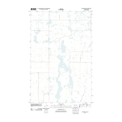
2011 Map of Palermo NW
USGS Topo · Published 2011About this map
Glacial potholes and prairie wetlands define this rural landscape in Mountrail County during the early 21st century. The terrain is dominated by a dense network of unnamed lakes and ponds, showing the characteristic topography of the North Dakota plains. Human footprint here is primarily etched through a systematic grid of section-line roads, including 74th St NW and 72nd Ave NW, which partition the agricultural land. In the southeastern corner, the path of Old Hwy 2 cuts across the cardinal grid, reflecting an older transportation corridor that preceded the modern highway system. This U.S. Geological Survey representation documents the precise drainage patterns and water levels of the region as they existed in 2011, providing a record of the hydrology and rural infrastructure in this remote corner of the state.
Find a feature on this map
12 named features on this map. Tap any name to fly to it.
Don’t see what you’re looking for? This feature index may not catch every label — zoom into the map to look around manually.
Map Details
Editions of this 2011 Palermo NW Map
This is the sole edition of this map. No revisions or reprints were ever made.
Other maps of this area

1949 · Mosquito Butte
USGS Topo · 1:24,000

1949 · Coulee
USGS Topo · 1:24,000

1950 · Kenmare
USGS Topo · 1:62,500

1953 · Williston
USGS Topo · 1:250,000

1957 · Williston
USGS Topo · 1:250,000

1969 · Stanley SE
USGS Topo · 1:24,000

1978 · Westby Lake
USGS Topo · 1:24,000

1981 · Stanley SE
USGS Topo · 1:24,000
1981 · Palermo NE
USGS Topo · 1:24,000

1981 · Palermo
USGS Topo · 1:24,000