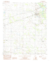
1984 Map of Palestine
USGS Topo · Published 1985About this map
Palestine serves as the primary settlement in this corner of St. Francis County, situated where the Chicago Rock Island and Pacific railroad meets local roads. The landscape is defined by the slow-moving L' Anguille River and its tributary Coffee Creek, which drain a region heavily partitioned into agricultural tracts. Evidence of rural life and early transportation networks appears in the scattered settlements of New Salem and Gill at the southern edge, and the uniquely named Hog Tusk to the west. This 1984 survey, produced from earlier manuscript drawings, preserves the drainage patterns and road infrastructure of eastern Arkansas before modern intensive development altered the rural township structure.
Find a feature on this map
10 named features on this map. Tap any name to fly to it.
Don’t see what you’re looking for? This feature index may not catch every label — zoom into the map to look around manually.
Map Details
Editions of this 1984 Palestine Map
This is the sole edition of this map. No revisions or reprints were ever made.
Other maps of this area

1939 · Wynne
USGS Topo · 1:62,500

1939 · Hunter
USGS Topo · 1:62,500

1940 · Brinkley
USGS Topo · 1:62,500

1940 · Marianna
USGS Topo · 1:62,500

1948 · Helena
USGS Topo · 1:250,000

1950 · Helena
USGS Topo · 1:250,000

1953 · Memphis
USGS Topo · 1:250,000

1955 · Helena
USGS Topo · 1:250,000

1956 · Memphis
USGS Topo · 1:250,000

1956 · Hunter
USGS Topo · 1:62,500