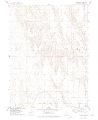
1974 Map of Palisade
USGS Topo · Published 1977About this map
Hayes and Hitchcock counties meet in this 1970s landscape defined by the drainage of Blackwood Creek. The terrain is deeply etched by significant draws including Government Canyon and Fish Canyon, illustrating the erosional patterns common to this part of the Nebraska plains. While the region is primarily defined by its topographical character, the presence of the Union Mission Cem provides a specific point of interest for genealogists and local historians tracking early rural communities and family burial sites in the area. Numerous well sites are distributed across the sections, reflecting the agricultural and resource-based activity of the mid-century period. Mapped from 1973 aerial photography, the survey also captures fine details such as selected fence and field lines that delineate land use patterns between the canyons.
Find a feature on this map
8 named features on this map. Tap any name to fly to it.
Don’t see what you’re looking for? This feature index may not catch every label — zoom into the map to look around manually.
Map Details
Editions of this 1974 Palisade Map
This is the sole edition of this map. No revisions or reprints were ever made.
Other maps of this area

1954 · McCook
USGS Topo · 1:250,000

1957 · McCook
USGS Topo · 1:250,000

1958 · McCook
USGS Topo · 1:250,000

1962 · Trenton
USGS Topo · 1:24,000

1962 · Culbertson NW
USGS Topo · 1:24,000

1962 · Stratton
USGS Topo · 1:24,000

1973 · Palisade
USGS Topo · 1:24,000
1973 · Beverly
USGS Topo · 1:24,000

1973 · Palisade SW
USGS Topo · 1:24,000
1973 · Burger Canyon West
USGS Topo · 1:24,000