
1973 Map of Palisade SW
USGS Topo · Published 1977About this map
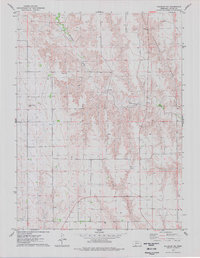
Frenchman Creek carves a significant valley across this section of Southwest Nebraska, defining the local landscape as it flows through the northern reaches of the quadrangle. In the early 1970s, the rural character of this borderland between Hayes and Hitchcock Counties is punctuated by the village of Hamlet and the presence of the Burlington Northern railroad. The map reveals an essential irrigation and water management system, including the Krotter Canal and a Gaging Station along the creek. Agricultural development is evident in the transition from the flat tablelands to the dissected terrain of Dry Canyon and Bobtail Creek. Local landmarks like the Pleasant Ridge Cem and the Richards Landing Strip offer specific points of interest for genealogists and local historians documenting the family and transport history of this high plains region.
Find a feature on this map
13 named features on this map. Tap any name to fly to it.
Don’t see what you’re looking for? This feature index may not catch every label — zoom into the map to look around manually.
Map Details
Editions of this 1973 Palisade SW Map
This is the sole edition of this map. No revisions or reprints were ever made.
Other maps of this area

1954 · McCook
USGS Topo · 1:250,000

1957 · McCook
USGS Topo · 1:250,000

1958 · McCook
USGS Topo · 1:250,000

1962 · Trenton
USGS Topo · 1:24,000

1962 · Stratton
USGS Topo · 1:24,000

1962 · Max NE
USGS Topo · 1:24,000

1973 · Palisade
USGS Topo · 1:24,000

1973 · Wauneta SE
USGS Topo · 1:24,000

1974 · Hamlet
USGS Topo · 1:24,000
1974 · Palisade NE
USGS Topo · 1:24,000