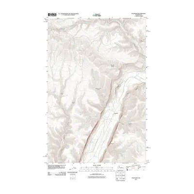
2011 Map of Palisades
USGS Topo · Published 2011About this map
Douglas Creek carves a deep path through the plateau of Douglas County, defining the settlement pattern of this rural Washington landscape. The community of Palisades sits nestled within this drainage, connected to the south by Palisades Rd and the small locality of Adrian. The surrounding terrain is a complex network of dry coulees and drainages with distinctive names like Airplane Canyon, Pegg Canyon, and Skookumchuck Canyon. Water is the lifeblood of this area, as seen in the presence of Skookumchuck Spring and Moore Spring. The map illustrates how human habitation is strictly tied to the floor of the Douglas Creek canyon, while the high, dissected ground of Wood Gulch and Straight Hollow remains largely undeveloped, showcasing a land-use pattern typical of the state's basalt coulee country.
Find a feature on this map
15 named features on this map. Tap any name to fly to it.
Don’t see what you’re looking for? This feature index may not catch every label — zoom into the map to look around manually.
Map Details
Editions of this 2011 Palisades Map
This is the sole edition of this map. No revisions or reprints were ever made.
Other maps of this area

1901 · Chelan
USGS Topo · 1:125,000

1912 · Malaga
USGS Topo · 1:48,000

1914 · Malaga
USGS Topo · 1:62,500

1920 · Colockum Pass
USGS Topo · 1:125,000

1922 · Colockum Pass
USGS Topo · 1:125,000

1953 · Ritzville
USGS Topo · 1:250,000

1957 · Wenatchee
USGS Topo · 1:250,000

1959 · Ritzville
USGS Topo · 1:250,000

1965 · Ritzville
USGS Topo · 1:250,000
1966 · Monument Hill
USGS Topo · 1:24,000