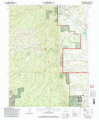
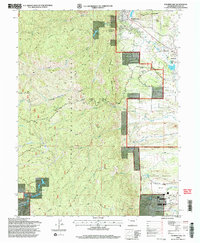
1994 Map of Palmer Lake
USGS Topo · Published 1998About this map
The Pike National Forest dominates this landscape, where the foothills of the Front Range meet the high plains. The transition is marked by prominent geological features like Sundance Mountain and the towering Mount Herman, with the town of Palmer Lake serving as a focal point at the northern edge. To the south, the northern reaches of the United States Air Force Academy are documented in detail, showing the Parade Ground, Athletic Fields, and the iconic Chapel alongside the residential layouts of Faculty Drive.
Find a feature on this map
60 named features on this map. Tap any name to fly to it.
Don’t see what you’re looking for? This feature index may not catch every label — zoom into the map to look around manually.
Map Details
Editions of this 1994 Palmer Lake Map
2 editions found
Other maps of this area

1893 · Platte Canyon
USGS Topo · 1:125,000

1893 · Colorado Springs
USGS Topo · 1:125,000

1894 · Pikes Peak
USGS Topo · 1:125,000

1894 · Castle Rock
USGS Topo · 1:125,000

1901 · Pikes Peak
USGS Topo · 1:125,000

1901 · Pikes Peak
USGS Topo · 1:62,500

1909 · Colorado Springs
USGS Topo · 1:125,000

1913 · Castle Rock
USGS Topo · 1:125,000

1942 · Colorado Springs
USGS Topo · 1:125,000

1948 · Colorado Springs
USGS Topo · 1:62,500