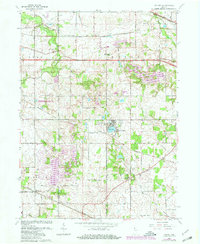
1962 Map of Palmer
USGS Topo · Published 1980About this map
Deep River and Salt Creek wind through this corner of Northwest Indiana, illustrating the rural landscape before late-century suburban expansion. The 1962 topography shows the importance of the regional rail network, with the Norfolk and Western, Chesapeake and Ohio, and Conrail lines crossing the terrain. These rail corridors intersect historical routes like the Old Lincoln Way, which parallels U.S. 30.
Find a feature on this map
32 named features on this map. Tap any name to fly to it.
Don’t see what you’re looking for? This feature index may not catch every label — zoom into the map to look around manually.
Map Details
Editions of this 1962 Palmer Map
3 editions found
Other maps of this area

1900 · Toleston
USGS Topo · 1:62,500

1934 · Porter
USGS Topo · 1:48,000

1940 · Porter
USGS Topo · 1:62,500

1953 · Leroy
USGS Topo · 1:24,000

1953 · Palmer
USGS Topo · 1:24,000

1953 · Gary
USGS Topo · 1:24,000

1953 · Crown Point
USGS Topo · 1:24,000

1953 · Hebron
USGS Topo · 1:24,000

1953 · Garyton
USGS Topo · 1:24,000

1953 · Valparaiso
USGS Topo · 1:24,000