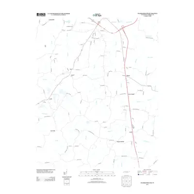
2013 Map of Palmer Shelter
USGS Topo · Published 2013About this map
Huntingdon Airport serves as a modern landmark in this section of Carroll County, where the landscape is defined by the headwaters and tributaries of Beaver Creek. The settlement pattern here follows the ridges and creek valleys, with small communities like Tate, Leach, and Anark linked by a network of rural roads such as Old Stage Rd and Tate School Rd. The map illustrates the geographical transition between upland areas like Marshall Hill and the numerous bottomlands drained by Reedy Cr and Brier Cr. Local history is preserved through the naming of small enclaves like Poplar Springs and the eponymous Palmer Shelter, reflecting a rural Tennessee landscape where agriculture and transport routes have shaped the development of distinct, dispersed neighborhoods over generations.
Find a feature on this map
110 named features on this map. Tap any name to fly to it.
Don’t see what you’re looking for? This feature index may not catch every label — zoom into the map to look around manually.
Map Details
Editions of this 2013 Palmer Shelter Map
This is the sole edition of this map. No revisions or reprints were ever made.
Other maps of this area

1936 · Clarksburg
USGS Topo · 1:24,000

1936 · Yuma
USGS Topo · 1:24,000

1936 · Vale
USGS Topo · 1:24,000

1936 · Center Ridge
USGS Topo · 1:24,000

1936 · Buena Vista
USGS Topo · 1:24,000

1950 · Yuma
USGS Topo · 1:24,000

1950 · Palmer Shelter
USGS Topo · 1:24,000

1950 · Vale
USGS Topo · 1:24,000
1950 · Buena Vista
USGS Topo · 1:24,000

1950 · Clarksburg
USGS Topo · 1:24,000