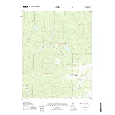
2017 Map of Palmer
USGS Topo · Published 2017About this map
The eastern foothills of the Saint Francois Mountains characterize this portion of the Mark Twain National Forest in Washington County. The settlement of Palmer occupies the western edge of the quadrangle, while Sunlight and Peoria anchor the eastern and southern reaches. The landscape is defined by a dense network of creek branches, including Hazel Cr, Trace Cr, and Brock Cr, which eventually feed into the Big River. Numerous small family and community cemeteries are scattered throughout the hills, such as the Jenkins Family Cem, Horton Cem, and Sitton Cem, providing a detailed record of rural residence patterns. Several modest water bodies, including Parole Lake and Gudaitis Lake, are tucked among the timbered slopes, while roads like Top Ozark Rd and Palmer Rd navigate the winding valley floors.
Find a feature on this map
61 named features on this map. Tap any name to fly to it.
Don’t see what you’re looking for? This feature index may not catch every label — zoom into the map to look around manually.
Map Details
Editions of this 2017 Palmer Map
This is the sole edition of this map. No revisions or reprints were ever made.
Other maps of this area

1906 · Potosi
USGS Topo · 1:62,500

1924 · Edgehill
USGS Topo · 1:62,500

1926 · Edgehill
USGS Topo · 1:62,500

1943 · Berryman
USGS Topo · 1:62,500

1943 · Boss
USGS Topo · 1:62,500

1945 · Berryman
USGS Topo · 1:62,500

1946 · Boss
USGS Topo · 1:62,500

1949 · Rolla
USGS Topo · 1:250,000

1953 · Rolla
USGS Topo · 1:250,000

1954 · Rolla
USGS Topo · 1:250,000