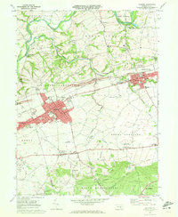
1969 Map of Palmyra
USGS Topo · Published 1972About this map
The Reading railroad corridor serves as the industrial and social spine of this Central Pennsylvania landscape, connecting the dense borough of Palmyra to Annville and the smaller enclave of Palmdale. To the north, the winding course of Swatara Creek and the remnants of the historic Union Canal reveal an older era of transport that predated the rail lines. The map captures a transition toward modern aviation with local facilities like Millard Airport and Reigle Landing Field situated amidst the rolling fields between settlements.
Find a feature on this map
74 named features on this map. Tap any name to fly to it.
Don’t see what you’re looking for? This feature index may not catch every label — zoom into the map to look around manually.
Map Details
Editions of this 1969 Palmyra Map
4 editions found
Other maps of this area

1891 · Lebanon
USGS Topo · 1:62,500

1892 · Hummelstown
USGS Topo · 1:62,500

1893 · Lebanon
USGS Topo · 1:62,500

1899 · Lebanon
USGS Topo · 1:62,500

1902 · Lancaster
USGS Topo · 1:62,500

1904 · Lancaster
USGS Topo · 1:62,500

1908 · Middletown
USGS Topo · 1:62,500

1924 · Hummelstown
USGS Topo · 1:62,500

1943 · Lancaster
USGS Topo · 1:62,500

1943 · Lebanon
USGS Topo · 1:62,500
Featured Places
- Hershey, Derry Township
- Palmyra, PA
- Campbelltown, South Londonderry Township
- Annville, PA
- East Hanover Township, PA