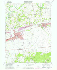
1969 Map of Palmyra
USGS Topo · Published 1977About this map
Palmyra and Annville serve as the primary hubs of this landscape, situated along the Conrail line where industrial activity is evident in the numerous quarries dotting the township boundaries. The 1974 photorevision highlights urban expansion in purple, particularly around Palmdale and the southern reaches of North Londonderry. Educational and religious landmarks are densely clustered here, including Lebanon Valley College and several rural congregations such as Kauffmans Ch and Brindnagles Ch.
Find a feature on this map
57 named features on this map. Tap any name to fly to it.
Don’t see what you’re looking for? This feature index may not catch every label — zoom into the map to look around manually.
Map Details
Editions of this 1969 Palmyra Map
4 editions found
Other maps of this area

1891 · Lebanon
USGS Topo · 1:62,500

1892 · Hummelstown
USGS Topo · 1:62,500

1893 · Lebanon
USGS Topo · 1:62,500

1899 · Lebanon
USGS Topo · 1:62,500

1902 · Lancaster
USGS Topo · 1:62,500

1904 · Lancaster
USGS Topo · 1:62,500

1908 · Middletown
USGS Topo · 1:62,500

1924 · Hummelstown
USGS Topo · 1:62,500

1943 · Lancaster
USGS Topo · 1:62,500

1943 · Lebanon
USGS Topo · 1:62,500
Featured Places
- Hershey, Derry Township
- Palmyra, PA
- Campbelltown, South Londonderry Township
- Annville, PA
- East Hanover Township, PA